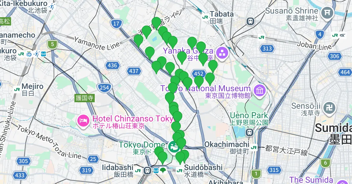
"B-guru" Sendagi & Komagome Route Map
Here is a bus stop map for the Sendagi & Komagome Route of Bunkyo City's community bus, "B-guru" (Beagle). Starting from Bunkyo Civic Center, the route heads past Tokyo Dome City, Hakusan, and Mukogaoka on its way to Sendagi and Komagome. It connects popular and handy spots like Rikugien Gardens, Komagome Hospital, and Nippon Medical School Hospital. Buses run every 20 minutes on weekdays, and every 30 minutes on weekends and national holidays.
2026.09.16
·Total ~11.7km
01
SPOT
Bunkyo Civic Center (Kasuga Station)
02
SPOT
Koishikawa Korakuen Entrance
03
SPOT
Koraku 1-chome
04
SPOT
Tokyo Dome Hotel
05
SPOT
Meets Port
06
SPOT
LaQua
07
SPOT
Bunkyo Koishikawa Clinic (Mita Line Kasuga Station)
08
SPOT
Bunka Shutter
09
SPOT
Queen's Isetan Koishikawa
10
SPOT
Sashigaya Elementary School
11
SPOT
Hakusan-shita
12
SPOT
Hakusan Station
13
SPOT
Hakusan-ue
14
SPOT
Mukogaoka 1-chome
15
SPOT
Mukogaoka 2-chome
16
SPOT
Nippon Medical School Hospital
17
SPOT
Sendagi 2-chome
18
SPOT
Sendagi Station (Dangozaka-shita)
19
SPOT
Special Nursing Home Sendagi no Sato
20
SPOT
Sendagi Elementary School
21
SPOT
Komagome Hospital
22
SPOT
Hon-Komagome 3-chome
23
SPOT
Fuji Shrine
24
SPOT
Showa Elementary School (Kamifujimae)
25
SPOT
Rikugien Gardens Entrance
26
SPOT
Namboku Line Komagome Station
27
SPOT
Rikugi Park Sports Ground Entrance
28
SPOT
Hon-Komagome 6-chome
29
SPOT
Sengoku Station
30
SPOT
Special Nursing Home Hakusan no Sato
31
SPOT
Toyo University
32
SPOT
Hakusan 5-chome
33
SPOT
Sashigaya Elementary School
34
SPOT
Hakusan 1-chome
35
SPOT
Bunka Shutter
36
SPOT
Mita Line Kasuga Station
Tap to zoom and moveClick to zoom and move